

Nerima Through Maps
Nerima Shakujiikoen Furusato Museum


Ends Tomorrow
SHARE
With the introduction of Western surveying techniques during the Meiji period, maps began to be produced with increasing accuracy. More than simply recording places, maps offer a way of visualizing how Nerima looked at different moments in its history.
Unlike the pictorial maps of the Edo period, modern topographic and administrative maps were based on precise measurements and standardized orientations, helping to shape a shared understanding of the region's geography. At the same time, illustrated guide maps, bird's-eye views, transportation maps, and other thematic maps highlighted particular places and attractions, making maps not only practical tools but also a means of presenting and promoting a region.
Through maps created for a variety of purposes, this exhibition traces the transformation of Nerima over time. Visitors are invited to explore the area through these maps and discover new perspectives on its history and development.
Unlike the pictorial maps of the Edo period, modern topographic and administrative maps were based on precise measurements and standardized orientations, helping to shape a shared understanding of the region's geography. At the same time, illustrated guide maps, bird's-eye views, transportation maps, and other thematic maps highlighted particular places and attractions, making maps not only practical tools but also a means of presenting and promoting a region.
Through maps created for a variety of purposes, this exhibition traces the transformation of Nerima over time. Visitors are invited to explore the area through these maps and discover new perspectives on its history and development.
Schedule Now in session | Jun 20 (Sat) 2026-Aug 16 (Sun) 2026 Ends Tomorrow Opening Hours Information
| ||||
|---|---|---|---|---|---|
| Fee | Free | ||||
| Website | https://www.neribun.or.jp/event/detail_f.cgi?id=202602131770944487 | ||||
| Venue | Nerima Shakujiikoen Furusato Museum https://www.neribun.or.jp/furusato.html | ||||
| Location | 5-12-16 Shakujiimachi, Nerima-ku, Tokyo 177-0041 | ||||
| Access | 15 minute walk from the Central exit of Shakujii-koen Station on the Seibu Ikebukuro line. | ||||
| Related images | Click on the image to enlarge it 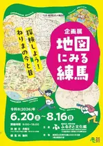 |
Back to Articles
SHARE
No comments yet